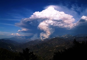
Did you know that the intense heat from fires can produce fire clouds?
A pyrocumulus cloud, known as a fire cloud, occurs from high surface temperatures. In Latin, pyro means “fire” and cumulus means “pile up”. These clouds are most commonly seen after fires, made by man or nature, and volcanic eruptions. When a large fire happens, it creates strong upward-moving winds that pull tiny bits of water and ash up. When the droplets of water condense on the ash from the fire, these strong winds can create pyrocumulus clouds.
Cumulus clouds resemble cauliflower heads and are commonly seen during Wisconsin summers. These puffy white clouds can reach up to 30,000 feet high. They are gray or brownish in color due to the ashes and smoke from the fire. Rain and lightning can occur when a pyrocumulus cloud develops into a cumulonimbus, also known as a thunderstorm. These elements can be beneficial and harmful – rain can put out the fire but the lightning could cause another wildfire.
Pyrocumulus clouds are a fascinating meteorological phenomenon. Seeing a cumulus cloud can tell a person a lot about the weather and the temperature of the surface.
[Source:
Wisconsin State Journal
]

